Construction of engineering-geological profiles in the form of the scheme |


|
|
Order of the task execution: - by means of the map editor to create linear object «GEOLOGICAL CUT»; - during digitizing a line of a profile (cut) it is necessary to use auxiliary modes of creation «K»-capture of an another's vertex (take vertex) and/or «I» a-copy of a vertex of the chosen object; - to choose on the panel of buttons a mode «Construction of engineering-geological profiles in the form of the scheme»; - to specify on a map a linear object «GEOLOGICAL CUT»; - to enter parameters of construction of a profile in dialog «Creation of the scheme of a profile»; - to open a map containing the drawing of the scheme of a profile; - to execute editing the scheme of a profile by means of the map editor.
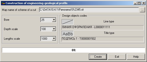
In dialog of a mode it is necessary to specify parameters of construction of the drawing: - to set a map name of the drawing of the scheme of an engineering-geological profile; - to enter a scale of depths (scale on a vertical axis of the drawing); - to enter a scale of lengths (scale on a horizontal axis of the drawing); - to specify codes of design objects.
Received drawing of an engineering-geological profile is a schematic drawing. Factually it is a set of the engineering-geological columns which have been stretched on all length of a profile in view of boreholes location. The given scheme is the initial information for formation of an engineering-geological profile. Editing of the scheme (merge of objects, interpolation of the metrics and so forth) is carried out by means of the map editor.
|