Analysis of the mathematical base |


|
|
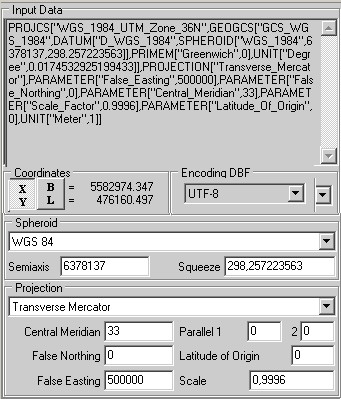
As a rule, complete set of Shape-set includes a file of description .PRJ. There is given description of coordinate system in which the coordinates of loaded objects are presented. Description of coordinate system includes the name and parameters of spheroid and projection.
The program as possible itself reads and identifies all the parameters stored in the file. PRJ. However, due to the fact that the data sets obtained from various sources, the same parameters (the name of projections, ellipsoids, etc.) can differ. For example, at the analysis of diverse data only for the name of spheroid WGS 84 have been found about ten variants: WGS 84, WGS_84, WGS_1984, WGS 1984, World_Geodetic_System_of_1984, etc. In case the program automatically could not identify some of the parameters or file PRJ is absent at all, but parameters of initial data are known, there is an opportunity to specify (or to refine) these parameters manually. Coordinates of the objects themselves can be presented in meters or degrees. At opening input data the program analyzes actually available coordinates. In case X accepts values more than 90, coordinates are automatically identified as geodetic. An example of available coordinates is displayed in the field of a dialog box. In case initial objects are described by geodetic coordinates, for a complete description of the initial mathematical base it is enough description of an initial spheroid (name). If the program itself could not identify initial spheroid and in the offered list it is absent, it is necessary to choose the "User" spheroid and to specify its parameters: semiaxis and factor of squeeze. In case of rectangular coordinates for unambiguous identification of the coordinate system it is necessary also the description of the initial projection (the name and parameters). Setting parameters of the mathematical base is performed only for identification of initial coordinate system. At creation of output map four variants are possible: 1. Output map already exists and supports recalculation into geodetic coordinates (add or change mode) - at loading (only if parameters of initial coordinate system are known) recalculation of coordinates into coordinate system of the output map is carried out. 2. Output map already exists and does not support recalculation into geodetic coordinates (add or change mode) - at loading (if parameters of initial system of coordinates are unknown) loading of coordinates without recalculation is carried out. 3. New map for known initial system of coordinates is created as «Mercator's navigation» on the spheroid WGS 1984. 4. New map for unknown initial system of coordinates is created with undefined type. It is necessary to remember, that for one session of loading the download of data package with identical initial coordinate system should be done. I.e. in the list of loaded data there should be data only with identical coordinate system. Thus, it is enough of one PRJ file for all package of loaded data. The sets which are not having the own file .PRJ will be identified on available one. |