Format Shapefle |


|
|
"Shape-file" (English Shapefile) - a vector format of geographical files. It is developed and supported by company Esri with the purpose of interoperability between products Esri and other programs. Format "Shape-file" allows to store the following various types of geometrical objects:
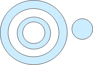
The separate file can store objects only of one type. When you load from Shape the objects of the Point type the point objects are formed. To each created object the unique semantic description from the corresponding record of DBF table is assigned. When you load from Shape the objects of Multipoint type the point objects are formed. To all created objects the identical semantic description from the corresponding record of DBF table is assigned. When you load from Shape the objects of Polyline type the linear objects are formed. At presence in a polyline more than one line they are drawn in the form of subobjects. To each created object the unique semantic description from the corresponding record of DBF table is assigned. When you load from Shape the objects of Polygon type the polygonal objects are formed. At presence in polygon more than one component the automatic analysis onto input of one object into another is made. Automatic definition of non-crossed basic contours and their subobjects, including taking into account the nesting («donut in donut») is carried out. To each created object the unique semantic description, from the corresponding record of DBF table is assigned. At creation (during the spatial analysis) of additional independent objects to them the identical semantic description is assigned.
Spatial analysis of components of one source polygon:
At processing objects of type PZ, LZ, SZ the objects having the three-dimensional metrics are formed. Data set in Shape format is a complete set of the files having identical names and different extensions. At export of data from Shape format the files are used: - main file (.SHP), containing the spatial (coordinate) description of loaded objects in the metric (X, Y) or geodetic (B, L) coordinate system; - file of attributive data (.DBF), containing the semantic description of loaded objects; - file of the project (.PRJ), containing the description of a mathematical basis of loaded data (description of parameters of coordinate system, spheroid, projection). The main file contains the spatial metric description of loaded vector objects in the form of sets of spatial coordinates of points (nodes). The file of attributive data has DBF format. One line of the table corresponds to one object in the main file. Conformity between objects and attributes is based on number of record. | ||||||||||||||||||||||||||||||||||||||||||||||||||||||||||