Advanced parameters |


|
|
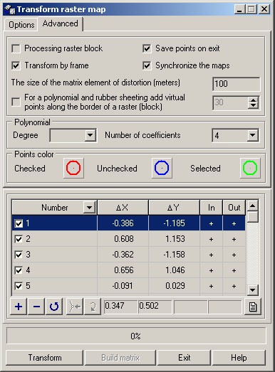
Mode «Processing raster block» defines how to interpret several rasters opened in the main window. If the mode «Processing raster block» is enabled, it is considered, that rasters are bound in one system of coordinates (i.e. are parts of a single image). In this case points are measured at once on all rasters, and then all rasters are together transformed. If the mode is disabled, it is considered, that rasters are not bound to each other. In this case the current raster is measured and transformed and at change of a current raster the measurement begin again.
Transform by frame If the input raster has a frame the area limited by a frame is transformed. For each raster several frames can be specified. Frame (or several frames) also can be set for several rasters. To set a framework it is possible in dialog « Data list of map» or using the panel «Rster Editor». If mode «Transform by frame» is disabled, irrespective of whether the raster has a frame or not, the entire area of a raster is transformed.
Save points on exit If enabled the saving the points, then when you close the task or change the current raster for disabled mode of processing rasters block, the measured points are saved into catalogs of coordinates (if at the moment of closing the names of catalogs are not defined, then the dialogue of a choice of a filename is called). If the measurements do not need to save, then disable the «Save points on exit».
Synchronize maps If measuring is carried out in two-window mode after calculating parameters of transformation, the image in the main and additional window synchronously is moved at enabling mode «Synchronize maps». If at measurement the blunders have been admitted, the relationship between the main and additional window will be defined incorrectly. In this case it is necessary to disable synchronization, remeasure rough points and then again re-enable synchronization.
To cut off by points At enabling this mode the area of transformation is set by sizes of area of reference points location.
The size of the matrix element of distortions The size of element of a created matrix of distortions is set in the input field «The size of the matrix element of distortions (meters)».
For a polynomial and rubber sheeting add virtual points along the border of a raster (block) For nonlinear types of transformation the nonlinear distortions out of the boundary of the location of control points are either not defined (for transformation by the type of linear, nonlinear rubber sheeting because of the impossibility of constructing a Delaunay triangulation outside the region of locating the control points) or have large values (as a polynomial surface is usually strongly deformed outside the area of the control points). To solve this problem virtual points on the boundary of transformation area are created, values of nonlinear distortions in which are installed equal to residual divergences of the nearest real control point at an affine transformation method. If the mode "Eliminate distortion by adding virtual points on the boundary of the transformation area" is disabled, recalculation into the output coordinate system out of the boundary of the location of control points is performed in different ways, depending on the type of nonlinear transformation: - for transformation by a type of linear, nonlinear rubber sheet the recalculation into output system of coordinates outside areas of location of control points is performed according to the formulas of the affine transformation, ie nonlinear distortions out of boundary of control points location are set equal to zero. This is done because the conversion options outside the boundary of the control points location , in principle, are not determined. - at polynomial transformation the conversions are feasible and outside the location area of control points, so the polynomial transformation is performed equally for the entire area of transformation. Number of added virtual points along the border of transformation area is entered into the input field «Number of virtual points». Minimum number of virtual points is four, for placing points at the corners of the transformation area. If the number of points is greater than four, they are evenly distributed along the border of transformation. For transformation using Delaunay triangulation (linear, nonlinear rubber sheet) it is recommended to enter the number of virtual points such that the distance between them was approximately equal to the average distance from the extreme control points to the border of transformation area. At polynomial transformation virtual points are used as additional points for making system of the normal equations at calculation of polynom coefficients. Inasmuch as outside location of control points for polynomial transformation usually arise inadmissible nonlinear distortion, then using virtual points you can reduce these distortions. But the increase in the number of virtual points leads to deformation of the surface of distortions inside the location area of the control points and an increase in the residual differences in control points. In practice a priori to determine the number of virtual points is difficult, so it is recommended to choose the number of virtual points empirically based on analysis of distortions matrices constructed with different number of virtual points.
Polynomial Indicate the number of coefficients by selecting the appropriate value from the list "Number of coefficients" or by indicating the degree of the polynomial.
Points color If points are not visible on a background of a color raster it is possible to change their color by clicking on the pictogram of a point image.
|