Program for stream load of OpenStreetMap data |


|
|
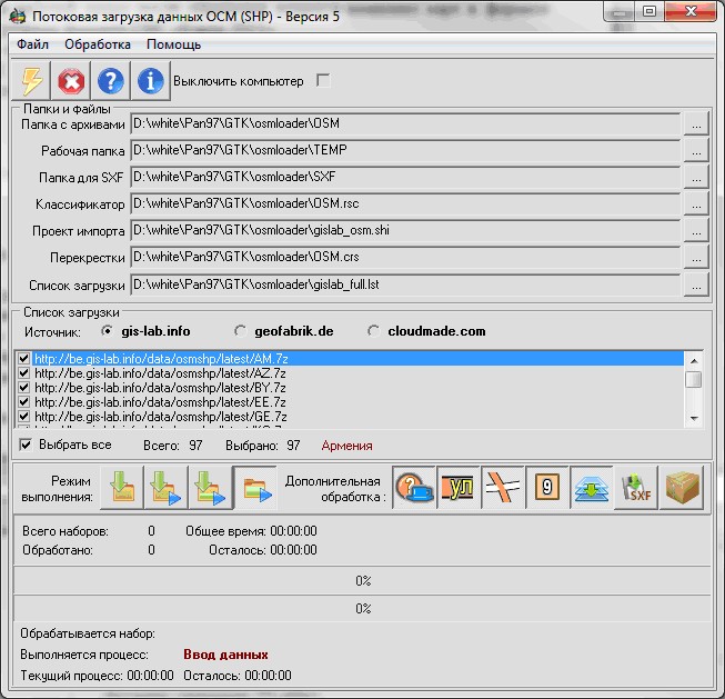
The program of stream loading the data is intended for automatic formation and maintenance in an actual condition of spatial data bank including digital maps in format SXF. Data source are sets in format ShapeFile, formed from the OpenStreetMap data and posted on the websites: GIS-Lab, Geofabric and Cloudmade. In any case, at the publication of formed spatial data the reference to ©Members OpenStreetMap is obligatory! Result of the program work is a set of maps in SXF format. Besides, in the working folder after processing there is a set of maps in format ShapeFile and in an internal format of GIS «Panorama 11». Internal parameters of the program are customized onto structure of databases as of 2/23/2014 For program execution necessarily presence of the installed program - archiver 7z.
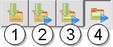
Data processing can be made in one of four modes:
1 - Only to load the data.
It can be used, for example, for primary loading all data with the subsequent distribution of processing onto several workstations.
2 - To load and to process;
The basic mode. There is produced a downloading all data marked in the list (irrespective of contents of input folder with archives) and processing according to the specified options.
3 - To finish loading and to process;
It can be used, for example, at rupture of communication with the Internet. There is performed an additionally loading the sets identified in the list of loading, but absent in the input folder with archives.
4 - To process contents of the working folder.
Processing of all sets containing in the input folder with archives is performed, irrespective of a condition of the download list.
Loading can be done from one of three accessible sites:
In view of that the internal structure of data, and also structure of configuration of sets on these sites are various, for each of them the program complete set includes its own file of the import's project (.SHI). In case the installed source of loading and a file of the import's project does not coincide, import can be executed with errors.
During work the program carries out the following processes:
1.Download of sets in accordance with the list and placing them in the folder for the source archives (until all sets will be downloaded, further processing will not be performed). 2.Sequential processing of sets including: - formation in a working folder of a subdirectory with a name of a loaded set, placing into it and archive deployment; - formation in the created subdirectory of a folder with name MAP; - map formation in folder MAP, conversion from a format - decoding points POI; - signing of streets; - designing of crossroads; - signing of structures; - final map sorting; - map's unloading into format SXF and its placing in a folder, specified for storage SXF; - archive packing.
Any of the specified processes at wish of the operator can be omitted. The application's installation package includes a set of files - download lists for each of the three sources. For Gis-Lab these files have the prefix «gislab_», for Geofabric - «geofabric_» and for Cloudmade - «cm_». All lists of loading are placed in the folder \LIST. On Gis-Lab site the data sets have the coded names.
Conformity of code and true names of regions on the site Gis-Lab:
|