Recoding OSM-objects |


|
|
The procedure for recoding OSM objects is a part of the technology of importing spatial data from OpenStreetMap.
The import technology is an automated procedure for converting data sets in the Shape format created on the basis of the OpenStreetMap project's data for the countries of the former USSR and the regions of the Russian Federation into the internal format of GIS "Panorama", with the further possibility of data application in server applications the GIS WebServer and GIS Server. To get started, you just need to download the full data set and run the task of importing vector data from the ArcView format in the GIS Panorama software (File - Import from ... - ArcView files (SHP)). This technology includes specialized configuration files and post-processing procedure. For more details click here.
Post-processing consists in refining the codes of individual objects and processing intersections of road network objects.
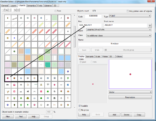
1) Refining codes of individual objects The need to refine the codes arises due to the fact that in the poi-point layer of the source data there are objects of different types and their belonging to a certain type that are in the presence of the value of one of several characteristics. In this case, it seems inappropriate to classify each of the options.
It is enough to describe, for example, in the classifier one object for display of any shops, and several types, for example, a supermarket, a automobile sales centre, to describe by individual objects. Characteristics of objects can accept various values. For each of these characteristics in the classifier there is a generalized type of object (the symbolic key of the object coincides with the name of the characteristic). In addition, the classifier defines a generalized type of objects contained in the poi-point layer. The objects of the corresponding classes that need to be displayed with a unique conventional symbol are described separately in the classifier. The possible value of the corresponding characteristic is indicated as the key for them. For example, bar or BAR (the register does not matter). Before performing the post-processing, it is necessary to select objects on the map that are to be recoded and to start the technology. After execution of post-processing, to the objects at which value of one of characteristics coincides with the object's key in the classifier, the appropriate code will be assigned. In case coincidence of value of the characteristic and an object key is not detected, an additional check is made onto coincidence of the name of the characteristic and the key of the object in the classifier (for assigning the generalized code).
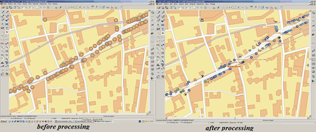
2) Processing intersections of road network objects.
Processing of intersections of road network objects is performed to improve the visual properties of the map. In case the map will be used in any automated systems and it is not supposed to be published, the processing of intersections can be avoided, since this increases the map objects.
3) Conducting a transaction log.
Logging changes is a function that saves the information necessary to restore the map to its previous consistent state in case of logical or physical failures. In the simplest case, the logging of changes consists in sequentially writing into the external memory of all the changes made with the map. The following information is recorded: - sequence number, type and time of change; - identifier of transaction; - an object that has undergone a change; - the previous state of the object and the new state of the object.
|