Vector objects orientation |


|
|
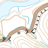
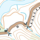
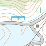
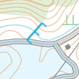
This mode is intended for orientation of vector symbols (marks) concerning linear objects. Examples of orientation are the matching of direction of the following objects: - bridges and dams along the linear roads and railways; - overpasses and pipes along linear rivers and brooks; - rapids perpendicular to rivers and brooks; - structures, parallel to the contours of linear and polygon roads.
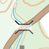
Bridges along roads (original view and result of processing)
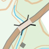
Dams along roads (original view and result of processing)
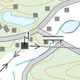
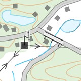
Overpasses along rivers (original view and result of processing)
Rapids perpendicular to rivers and brooks (original view and result of processing)
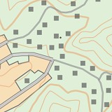
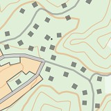
Structures, parallel to contours of roads (original view and result of processing)
Parameters of processing: - Maximum distance between a linear object and the first point of a vector symbol. For orientation of the symbols having a metric binding to analyzed objects (for example: vector bridges, rapids, overpasses tied to contours of linear roads or rivers), it is recommended to set the value to 1 meter on the terrain. For orientation of the vector symbols that do not have a metric binding to analyzed objects (for example: structures, located near roads), it is recommended to set the value to 100 meters on the terrain. - Radius for determining direction at the specified distance from the vector symbol (for example: dams, rapids). This parameter is used only for those symbols that have a Predefined direction in the map classifier. The radius value is used for defining the direction of current of the linear river at the point where the vector symbol is located. The vector symbol is oriented so that the dots of the symbol (dam or rapid) were displayed from the side of the relief's lowering. For defining difference of heights, it is recommended to set the value of 10 meters on the terrain. - Mark orientation determines the location of the vector symbol relative to the linear object (parallelly or perpendicularly). Bridges, dams and structures are located parallelly to roads. Overpasses and pipes are located in parallel to rivers and brooks. The rapids are located perpendicularly to the rivers. - Turn angle of linear object defines necessity of orientation of vector symbols. This parameter is used at orientation of vector structures that are not tied to the contours of the analyzed objects (linear and areal roads). If the turn angle is less than the specified one, the orientation of the nearby symbol is not performed. The recommended angle is 20 degrees.
|