Parameters of converting |


|
|
For getting a map in DXF format it is stipulated two modes of converting: - Getting of DXF file with all objects of a map, i.e. with the customized and not customized conformity between objects of classifiers. - Getting of DXF file only with the map objects, for which conformity between objects of classifiers is customized. In this case in the end of process of converting it will be offered to you to see the report in which objects will be specified which did not participate during converting. These modes are set on the panel: Objects which are absent in file of conformity: Create or Not create (it is set by default). If at converting it has been specified - Not create the objects which are absent in a file of conformity then in this case into DXF format all the map objects will be translated for which parameters of converting are customized. Thus, parameters for converting object into DXF format are defined in a file of conformity by a key of object. The object is considered as the customized one if the name of a layer, localization, a conventional symbol are specified. If at converting it has been specified - Create the objects which are absent in a file of conformity, in this case objects for which parameters of converting are not set up will be translated into DXF format with parameters by default. For such objects it is necessary to specify Customizing by default for converting in a window which appears automatically at a choice of Create mode.
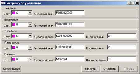
Here it is necessary to specify key parameters for objects of each type of localization and to press Accept button. Parameters by default are saved in a file of conformity. Further it is necessary to specify one of six modes of forming a name of a layer into which the not customized objects will be placed into DXF format: - by a serial number of a layer in a map (Number of a layer), - by a full name of a layer (Name of a layer), - by a short name of a layer (Key of a layer), - by the full name of object (Name of object), - by the short name of object (Key of object), - by the short and full name of object through a sign of underlining (Key_Name of object). Also the opportunity of a choice of accuracy of unloading the map objects coordinates is stipulated. At loading a map the accuracy of coordinates is automatically defined. It can vary by the user depending on demanded result. The mode of precision is set on the Metrics precision panel. By default the precision of the metrics is set 6 signs after a comma. To unload the semantic information on objects (semantics), it is necessary to choose Database - Create mode. In this case in a directory of the specified map the «Database of a sheet <map file name>» directory for converting will be created where instead of <map file name> a name of a file will be substituted. In the given directory *.dbf tables shall be placed for each layer of RSC classifier. A name of a file *.dbf is a a key of a layer.
|