Process of implementation of exporting layers of DTM to the geo database ArcSDE Oracle |


|
|
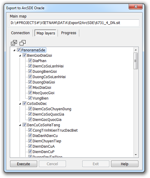
In order to export the layers of DTM to the geo database ArcSDE Oracle, it is necessary to open DTM in GIS Panorama. In order to minimize possible errors during the export procedure, it is strongly recommended that you follow the control procedure of DTM and to correct any errors in the original data that are detected. Call the task «Export to ArcSDE Oracle» using the menu «Tasks – Run applications» (or by pressing the «F12» button). In the task dialog «Export to ArcSDE Oracle», it is necessary to fill the connection parameters with the server of database Oracle and to execute connection. The connection must be established on behalf of the user SDE (or another user with the same authority in the geo database). If you successfully connect to the database Oracle, on the tab «Map layers» will display a list of tables registered in the geo database ArcSDE Oracle, where spatial data is stored in the layers of DTK. If it is necessary, on this tab, you can select individual tables, in which DTM data will be downloaded. In this way, the composition of DTM layers is selected for export to the geo database ArcSDE Oracle. By default, all tables are selected.
Selecting the composition of DTM layers for export to the geo database ArcSDE Oracle
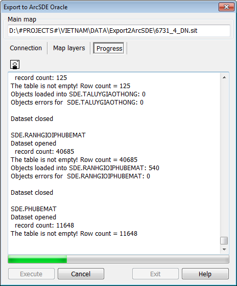
Procedure for exporting layers of DTM during the execution
If the connection to the database is successful, the button «Run» becomes available. When it is clicked, the process of exporting the layers for DTM to the selected tables in the geo database begins. Objects that do not belong to the selected tables are skipped. During the export, a protocol is maintained, in which messages about the execution process are recorded. Errors are also output to this protocol. The protocol can be saved to a text file on the disk using the button If there are errors, they should be analyzed, and their causes eliminated. After eliminating the causes of errors during export, the export procedure must be carried out first. Before re-exporting, all previously downloaded data from the geo database must be deleted. Instead of clearing the geo database, you can delete it entirely and create a geo database again: Creation of a new database in DBMS Oracle Creation of the geo database ArcSDE in DB Oracle Configuring the geo database to access spatial data from external clients Creating additional software objects in the geo database
The example of an error associated with the incorrect metric in the source data (self-intersection of the object contour): Database: ORA-20015: Error generating shape from binary: Invalid polygon closure (20813). ORA-06512: at "SDE.ST_GEOMETRY_SHAPELIB_PKG", line 237 ORA-06512: at "SDE.ST_GEOMETRY_OPERATORS", line 162 Can't process object: 17 Error write object 17 from list 1
The example of an error related to incorrect semantics in the source data (there is no value for the characteristic that is mandatory for filling): Database: ORA-01400: cannot insert NULL into ("SDE"."DOANTIMDUONGBO"."LOAIKETCAU") Can't process object: 3677 Error write object 3677 from list 1
The example of an error related to the incorrect metric in the source data (the output of the metric beyond the limits of the dimensions defined by the coordinate system code in the database): Database: ORA-20015: Error generating shape from binary: Coordinate system is out of bounds (20807). ORA-06512: at "SDE.ST_GEOMETRY_SHAPELIB_PKG", line 237 ORA-06512: at "SDE.ST_GEOMETRY_OPERATORS", line 162 Can't process object: 2047
The example of an error related to the application of a non-standard coordinate system, to which it is impossible to perform the transformation of the geo database by internal means (see requirements): Database: ORA-29875: failed in the execution of the ODCIINDEXINSERT routine ORA-20085: Insert Spatial Reference SRID 3405 does not match SDE.DUONGBINHDO.SHAPE registered Spatial Reference SRID 300002 ORA-06512: at "SDE.ST_DOMAIN_METHODS", line 1986 Can't process object: 3406
The error codes provided by the geo database ArcSDE have values starting at 20001 and higher. The error description by its code can be found in the documentation on ArcGIS, including online - http://webhelp.esri.com/arcgisserver/9.3/java/geodatabases/sql_exc1207716883.htm. Errors that have code 20000 or less or 21300 or more are related to messages DBMS Oracle. The error description for these codes can be specified in the documentation for DBMS Oracle, including online – https://docs.oracle.com/cd/B14117_01/server.101/b10744/toc.htm.
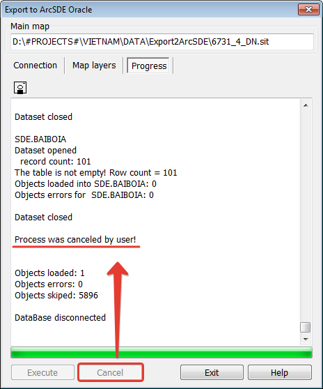
You can interrupt the export of DTM layers to the geo database ArcSDE. To do this, click the button «Cancel». After the export is canceled during the run, all previously downloaded data from the geo database must be deleted before the re-export procedure. Instead of clearing the geo database, you can delete it entirely and create a geo database again: Creation of a new database in DBMS Oracle Creation of the geo database ArcSDE in DB Oracle Configuring the geo database to access spatial data from external clients Creating additional software objects in the geo database
Interrupting the export process during execution
|