Options of parameters of functioning of a task |


|
|
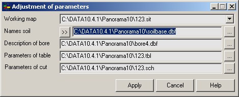
Dialog is intended for a choice of a working map, setting up a legend of geological beddings and soils, files for storage of the attributive information.
Working map - a map, created on the basis of Geology.rsc classifier. If there is no map, created on the basis of Geology.rsc, modes of the task will not be made active. If in one document (one window) some maps are opened, choose necessary, using the opportunities of dialog. If some documents (some windows) are opened, at switching between them the control of presence of a working map is carried out. At absence of a working map in the list of maps of the active document, the task is automatically closed. Names of a soil - the description of names of geological beddings and conventional symbols for their displaying on a map. Descriptions of geological beddings are stored in a special file - geosoil.cod. or in the file of a database specified by the user.At absence of a file it is created automatically in a folder of a map. At desire it is possible to use files created earlier. The button located to the right of an element, displaying a file name, is intended for a choice of a name of existing file. «Soil description» dialog is intended for conducting the description of geological beddings. The call of dialog is carried out by pressing the button located to the left of an element, displaying a file name.
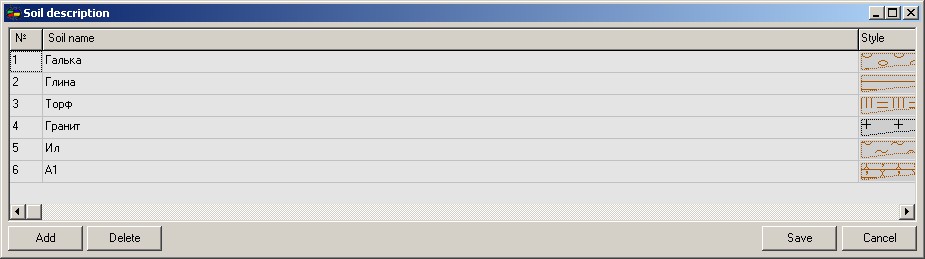
In «Soil description» dialog it is possible to add new records or to delete the existing one. Input of a soil name in a manual mode and a choice of a style of object from library of conventional symbols (Geology.rsc) are stipulated. It is possible to add, delete and edit. Description of boreholes - a special file, intended for storage of the information in points of engineering-geological researches (boreholes). At absence, the file is created by the program automatically: by filename of a map plus geo extension. At a choice of .dbf extension for files of descriptions of boreholes two tables of a database will be created. Into the table, which name is specified in the field «Boreholes description», data about points of engineering-geological researches are entered. The second table is formed automatically, by addition to a filename of a line layers. Into this table the data about a soil for all boreholes are placed. Parameters of the table. File MapName.tbl is created by the program automatically for each new map. The information on parameters is stored in it (sizes, titles and so forth) for construction of engineering-geological columns. Parameters of the scheme. File MapName.sch is created by the program automatically for each new map. The information on parameters is stored in it (sizes, titles and so forth) for construction of engineering-geological profiles.
|