Updating semantics |


|
|
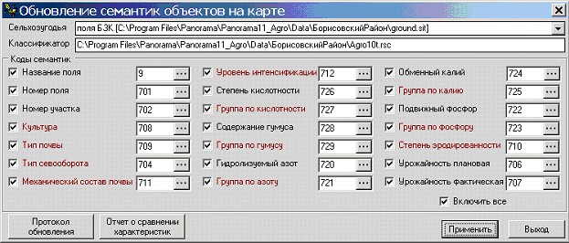
Attributive characteristics of an arable land can be stored in semantics of map objects or in tables of external database. The mode «Update semantics» is intended for entering/updating of the semantic data of object or the tabular data of fields passports, the mode is called by the button Dialog «Update semantics of objects on the map»:
The mode provides two-way update:
The first variant is used for construction of thematic cartograms. In addition, the mode can be used for preparation of a map for download onto the mobile device, because on the mobile device an access to a database either is impossible, or is very limited. The second variant of updating is used for loading the updated data about sections of fields, by results of field inspection with using the mobile devices.
For updating semantics by a necessary condition is the presence of link between record in a database and object on a map. Thus, the object should be polygonal «SEPARATE SECTION of the ARABLE LAND» (code 79000001).
At updating the data containing final values of characteristics, complications does not arise. However most of characteristics of an arable land is selected from references. Mechanism of semantics with type «code from the classifier» is applied to provide references on list-box data in a map of fields.
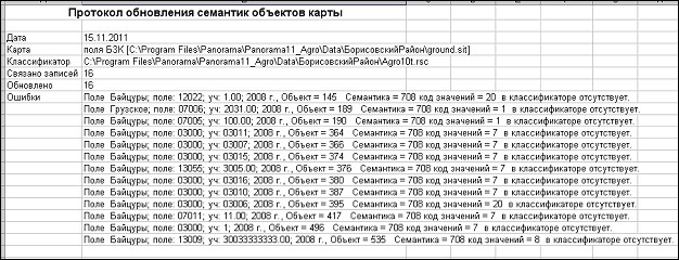
For example, for semantics «CULTURES» the list of the coded values should correspond to the reference «Cultures» from a database. In practice it often occurs that the data of coded semantics of the map classifier do not correspond to the reference data of database. During updating the program finds all mismatchings and forms the updating protocol and the report on mismatching the characteristics.
Protocol of updating semantics:
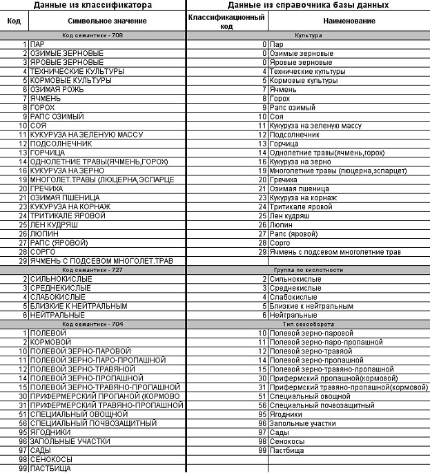
Report about comparison of characteristics:
For correct creating the thematic maps the data of the classifier and references of a database should be identical, otherwise the user must decide whether to change the data in the classifier or in references of the database. SYSTEM provides processing of following themes of the reference with coded semantics:
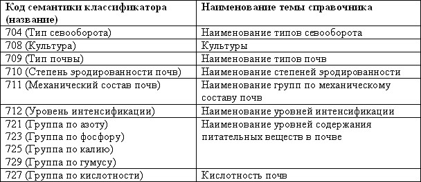
- Culture (reference «Normative-help information aboutn cultures», section "Cultures"); - Type of ground (reference «Base references», section «Name of ground types»); - Soil structure (reference «Base reference», section «Name of groups by mechanical structure of soil»); - Degree of erosion (reference «Base reference», section «Name of erosion degrees»); - Group of acidity (reference «Normative data about soil structure», section «Acidity of soils»); - Group of humus, nitrogen, kalium, phosphorus (reference «Base reference», section «Name of levels of the contents of nutrients in the soil»); - Level of an intensification (reference «Base reference», section «Name of intensification levels»); - Type of a crop rotation (reference «Base reference», section «Name of crop rotation types»). In the listed references it is necessary to fill the field «Classification code». This is a whole numerical value. On the form of dialog the coded semantics are highlighted by color. Editing of the classifier in SYSTEM is not stipulated. Use the specialized software for editing. At updating values in the classifier, it is necessary to consider conformity of a conventional symbol of the object's code belonging to a series of objects, and data of database references.
Conformity of codes of semantics and themes of the database reference:
Result of working the dialog «Updating the semantics of objects on a map» is the updated semantic information about objects of a map according to database information.
|